
Three locations that define what the Westfjords actually are
The Westfjords overview article on this site covers the region broadly — the driving, the wildlife, the solitude, the light in October. This article goes deeper into three specific subjects that each deserve more than a paragraph: Dynjandi waterfall, the Garðar BA 64 shipwreck, and the geothermal hot pools that are scattered across the region with a generosity that feels almost deliberate.
These three are not random selections. Together they represent what the Westfjords offer that nowhere else in Iceland does: a waterfall of extraordinary scale with almost no visitors, an aurora foreground that no other location in Iceland replicates, and the experience of soaking in geothermal water in complete solitude while a fjord stretches out in front of you and sleet falls on your face.
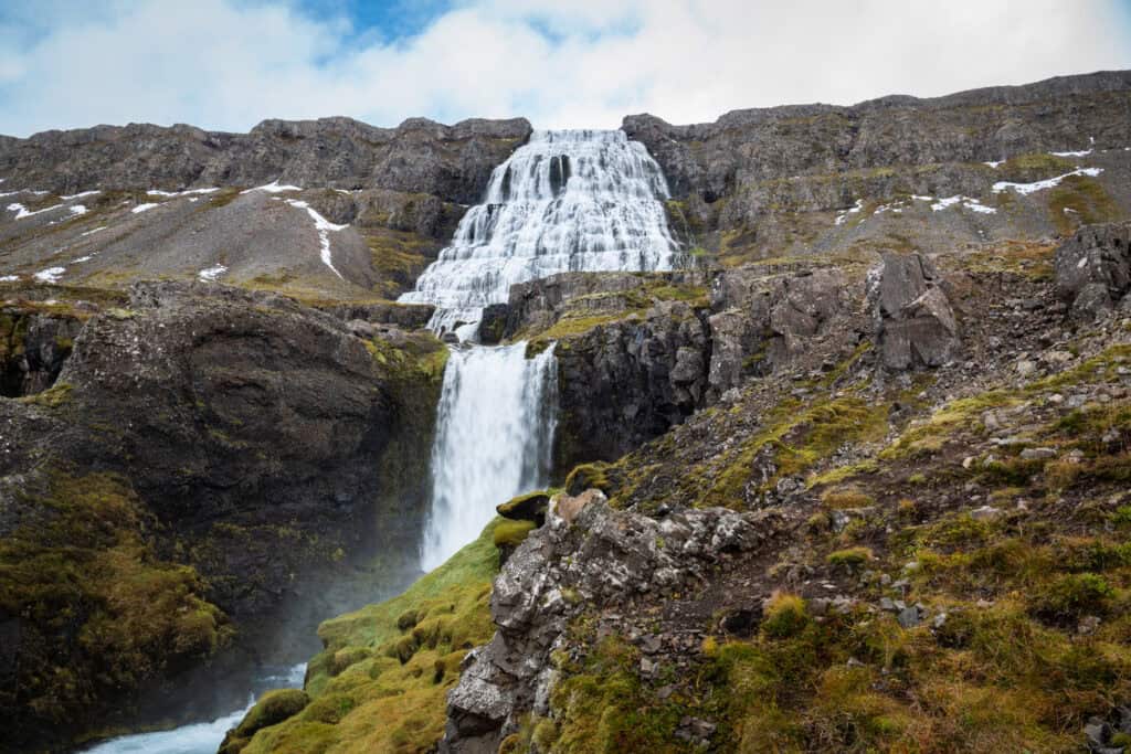
Dynjandi — The Westfjords’ Cathedral
Dynjandi is Iceland’s most dramatic tiered waterfall — a series of cascades that widen as they descend, the largest drop spanning approximately 30 metres across at its base after falling 100 metres in total. The name means “thunderous” in Icelandic. Standing at its base, that description is accurate.
The waterfall sits in a protected area on the shores of Arnarfjörður, accessible via Route 60. It is one of the Westfjords’ most visited locations — which, in regional context, means a car park that fills to perhaps twenty or thirty vehicles at peak season. Compared to Iceland’s south coast waterfalls, it is empty.
Getting There
The car park is directly off Route 60 on the southern shore of Arnarfjörður. Parking costs 750 ISK, payable by card at the car park. The path leads past six smaller falls — Hæstahjallafoss, Strompgljúfrafoss, Göngumannafoss, Hrísvaðsfoss, Kvíslarfoss, and Bæjarfoss — before reaching the main fall. Each of the smaller falls is a subject in its own right. The temptation to walk straight past them toward the main event is understandable and worth resisting.
Note: road improvement works were underway near Dynjandi in 2025 and the access road may be partially or fully paved by the time you visit. Check current conditions at road.is before travelling — the surface may be significantly better than older accounts suggest.
The path takes approximately 20–30 minutes to the base of the main fall. The surface is marked and maintained. Stay on it — the vegetation around the path is the slow-growing ground cover that defines Westfjords ecology and does not recover quickly from footsteps.
Photographic Tips
The tiered approach: The smaller falls on the ascent are best photographed individually rather than as part of a wide composition. A moderate telephoto (70–100mm) isolates each fall against the surrounding rock and vegetation. In October, the autumn colour in the hillside adds warmth to what would otherwise be a cool palette.
The main fall: Wide angle (16–24mm) is the starting point for the full cascade — the widening form from top to base works naturally in a vertical frame. A 6-stop ND filter in overcast light gives shutter speeds in the 5–15 second range that smooth the water without losing the sense of volume.
The base composition: From the base of the main fall, looking up through the cascade gives a perspective unavailable from further back — the water fills the frame from the cliff edge above to the pool below. This position is wet. Lens cloths matter more here than at almost any other Iceland waterfall.
If you are visiting with a companion, use them for scale. Positioning a person at the base of the main fall — or at one of the intermediate falls on the ascent — and photographing from further down the path gives the image an immediate sense of the waterfall’s true height. A figure that appears small against the cascade communicates scale more effectively than any wide angle lens alone.
Autumn: October at Dynjandi is the season I would recommend. The amber and rust of the hillside vegetation sits against the white water and the grey rock with a warmth that summer’s green cannot match. The visitor numbers are minimal. The light in the late afternoon comes from the west across Arnarfjörður and catches the fall face directly.
The view from the car park: Before ascending, turn around. The view across Arnarfjörður from the car park — the fjord, the mountains on the far shore, the scale of the landscape — is worth photographing in its own right. It is the context that makes Dynjandi what it is.
Leave No Trace at Dynjandi
Dynjandi sits within a protected area. The path system is the result of careful planning to concentrate foot traffic on surfaces that can absorb it. The vegetation on either side — particularly around the smaller falls where the temptation to find a better angle is strongest — is fragile and slow-recovering.
No drone flight without a permit from the Nature Conservation Agency of Iceland — nattura.is. The fjord and mountain backdrop make aerial photography here genuinely tempting; the permit process makes it legitimate.
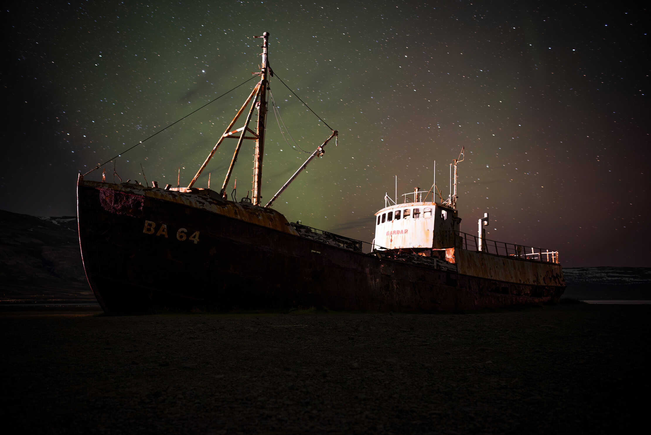
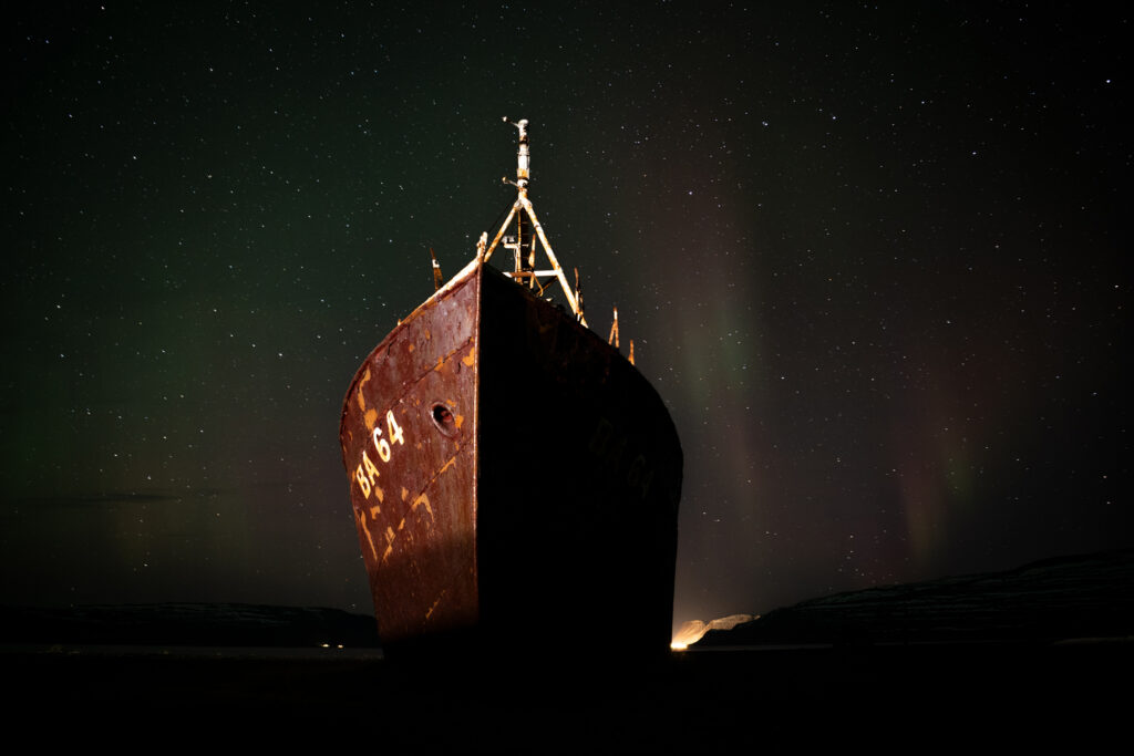
Garðar BA 64 — Aurora Over the Oldest Steel Ship in Iceland
The Garðar BA 64 sits on the beach at Skápadalur in Patreksfjörður, accessible via Route 612 — the same road that leads toward the Látrabjarg bird cliffs. The wreck is approximately one kilometre from the junction with Route 62 and is directly visible from the road. A large car park is located right beside the site.
It is the oldest steel fishing vessel in Iceland. It has been here long enough that the beach has shaped itself around it. And on a clear October night, with the aurora visible overhead and the stars sharp in the absence of any artificial light, it is one of the most extraordinary photography subjects I have encountered in six Iceland trips.
Finding the Location
The Garðar BA 64 sits on the beach at Breiðavík, near Patreksfjörður in the southern Westfjords. From Patreksfjörður town, follow Route 62 south and then the coastal road toward the beach. The wreck is visible from the road.
The beach approach is straightforward at low tide. At high tide, access to the seaward side of the vessel is limited — the water reaches the hull at certain tide heights. Check conditions before approaching and do not position yourself between the hull and the incoming tide.
Daytime Photography
In daylight, the Garðar rewards a telephoto lens that isolates sections of the hull — the rust patterns, the faded lettering, the structural details of a vessel that has been weathering for more than four decades. The contrast between the warm orange-brown of the rusted steel and the grey of the Westfjords sky is strongest in overcast light.
A wide angle lens from the beach level, with the hull curving across the frame and the fjord visible behind, captures the scale and the desolation of the subject together. Low position — camera close to the beach surface — emphasises the size of the vessel.
Drone use at Garðar BA 64 is subject to standard EU regulations — no national park permit is required here. The location is not within a protected area, and the open beach and fjord offer extraordinary aerial perspectives. Register at flydrone.is, check kort.gis.is/mapview/?app=dronar for any active restrictions, and follow the standard altitude limits. The rusted hull and surrounding beach from above produce compositions that ground-level photography cannot replicate.
Note on aurora drone photography: technically, flying a drone at night for Northern Lights images requires a Specific Category authorisation from ICETRA — standard Open Category rules only permit daylight and civil twilight flights. For most visitors this authorisation is not practical to obtain. Aurora photography at this location is therefore best done from the ground.
Aurora Photography
The ship is at its most extraordinary at night under the Northern Lights. The combination of a manmade structure with the geological drama of the aurora overhead produces the kind of image that requires everything to align — clear sky, aurora activity, and the willingness to be standing on a dark beach in October at midnight.
I was there when it aligned. The image is the titelbild for this article.
Practical aurora notes for this location:
- The beach is completely dark — there is no artificial light for kilometres. Bring a headlamp and set up your composition in whatever remaining daylight is available before the aurora appears
- The beach surface is uneven and the approach from the road involves loose rock. Move carefully in darkness
- Check the aurora forecast on Veðurstofa Íslands in the evening and again at midnight — activity can begin after 11pm even when the early evening forecast is low
- A wide angle lens (14–20mm), f/2.8, ISO 1600–3200, 10–20 second shutter speed is the starting point. Adjust based on aurora intensity
- The BA 64 lettering on the bow faces roughly east — the aurora visible from the north requires positioning yourself on the seaward side of the vessel, looking back toward the hull with the sky above and behind it
A note on arriving at night: when we drove to the wreck after spotting the aurora from the restaurant, our headlights swept across the beach and directly into the compositions of photographers who were already set up. Long exposure shots ruined in an instant — something we only realised afterwards. If you arrive after dark with others already shooting, turn off your headlights as early as safely possible before reaching the parking area, or wait until their exposures are complete before pulling in. Your eyes adjust to the darkness quickly — within a few minutes you can move around the beach and set up equipment without any artificial light. The darkness is an asset, not an obstacle.
Aurora Photography — Garðar BA 64
Night shoot at the shipwreck — preparation checklist
Before You Leave the Guesthouse
At the Beach
Starting point settings for Garðar BA 64 aurora
The headlights moment: When we drove to the wreck after spotting the aurora from the restaurant, our headlights swept directly into the compositions of photographers already set up on the beach. Long exposures ruined in an instant — something we only understood afterwards. If you arrive after dark with others already shooting, turn off your headlights as early as safely possible before the car park, or wait. Your eyes adjust to the darkness quickly. The darkness is not an obstacle.
Leave No Trace at Garðar BA 64
The wreck and the beach are accessible to the public. The vessel itself is not a climbing structure — the rusted metal is structurally unpredictable and a fall inside or from the hull is serious. Photograph from the beach.
Do not remove any part of the wreck as a souvenir. It is a historical vessel and its physical integrity is part of what makes it worth photographing.
Westfjords Hot Pools — The Real Geothermal Experience
Iceland has developed geothermal bathing into an industry — the Blue Lagoon, the Sky Lagoon, the Mývatn Nature Baths. All are worth knowing about. None of them are what I think of when I think about Iceland’s hot springs.
What I think about is a road through the Westfjords, an unexpected pool beside it, and no one else for as far as I could see.
Hot Pools
Westfjords geothermal pools — what each one offers
The rule for all three: No soap, no foreign substances of any kind. These are natural or community pools — contamination causes measurable damage and is visible to the next person who arrives. Use them as you found them. They are free because the community maintains them that way.
Reykjafjarðarlaug
We were driving along the road through Reykjafjörður when the pool appeared. There was no particular signage that prepared us for it. Suddenly there was a swimming pool-sized geothermal bath beside the road, with a view across the fjord that extended to the mountains on the far shore — and not a single other person.
Reykjafjarðarlaug has two pools: a hot one and a cooler one. The temperature difference is significant enough that moving between them gives your body a contrast that the single-temperature commercial pools don’t offer. The fjord view from the water is extraordinary — the scale of the landscape visible from a horizontal position in warm water at the end of a long driving day is an experience that no Blue Lagoon admission fee replicates.
Practical information: The pool is freely accessible, maintained by the local community, and open year-round. It is located in Reykjafjörður, accessible from Route 60 via a turn onto Route 623. A changing area is available on site. No facilities beyond that — bring everything you need.
Photography: The combination of the pool edge, the fjord, and the mountains beyond works as a wide angle landscape composition. Early morning or evening light from the west catches the fjord surface directly. Other bathers: photograph the landscape, not the people, without consent.
Drangsnes Hot Tubs
At the end of the road in the small village of Drangsnes on the Strandir coast, three concrete tubs sit directly on the seashore. The ocean is on the other side of a low wall. The sound of the water is constant.
We arrived in sleet. The combination of cold rain on the face and geothermal water around the body is one of those Iceland experiences that sounds uncomfortable in description and is actually perfect. The tubs are at different temperatures — the hottest is genuinely hot. Moving between them while sleet falls horizontally across the Húnafjörður is exactly the kind of thing that makes the Westfjords memorable for reasons that have nothing to do with photography.
And then the light changed, and the sleet softened, and the fjord appeared through the weather — and it was photographically extraordinary.
Practical information: The Drangsnes tubs are freely accessible and open year-round. The village is at the end of Route 645 on the Strandir coast — a significant detour from the main Westfjords circuit, but the Strandir coast rewards photographers who make the effort. The coast north of Drangsnes is one of Iceland’s least visited stretches of landscape.
Photography: The tubs themselves are modest concrete structures — the photography here is in the context, not the subject. A wide angle lens from outside the tub area, with the ocean visible behind and the mountains of the far shore in the distance, captures what makes the location remarkable. In weather — rain, sleet, low cloud — the atmosphere is at its strongest.
Drone: Drangsnes is not within a national park. Standard EU drone regulations apply. The Strandir coastline from the air is extraordinary — check kort.gis.is/mapview/?app=dronar for any local restrictions before flying.
Combining These Three Locations
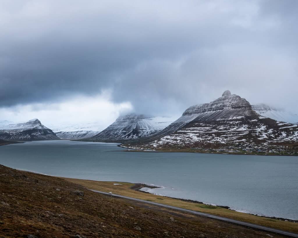
All three are in the southern and central Westfjords and can be combined into a two-day itinerary from Ísafjörður or as part of the peninsula circuit:
Day 1: Drive south from Ísafjörður via Route 60 to Dynjandi — allow three hours for photography. Continue to Patreksfjörður for the night. Evening: check aurora forecast. If conditions favour it, return to Garðar BA 64 after dark.
Day 2: Morning at Garðar BA 64 in daylight if not visited the night before. Drive the Strandir coast via Drangsnes — Route 645 from Hólmavík. End the day at Reykjafjarðarlaug on the return toward Ísafjörður.
This itinerary requires flexibility — the driving distances in the Westfjords are consistently longer than the map suggests. Allow time for both the road and the locations.
Suggested Itinerary
Two days — Dynjandi, Garðar BA 64, and the hot pools
The Westfjords driving rule: every journey takes longer than the map suggests. The roads follow every contour of every fjord. What looks like 80km on a map may take two hours. Build that time into every day — and use it to photograph the drive, not just the destinations.
Practical Notes
Accommodation: Patreksfjörður has guesthouses and a hotel. Ísafjörður is the region’s main town with the widest options. In October, confirm that your chosen accommodation is open — some smaller guesthouses close for the winter.
Fuel: Fill up at every opportunity. The Westfjords have fuel stations in the main towns but gaps between them are long. Running out of fuel in the interior of the Westfjords is a serious inconvenience.
Weather: The Westfjords receive significant rainfall. The weather changes quickly and the mountain passes that connect the fjords can close in severe conditions. Check Veðurstofa Íslands daily and road.is before every significant drive.
Sources
- Nature Conservation Agency of Iceland — nattura.is
- Veðurstofa Íslands (Icelandic Meteorological Office) — vedur.is
- Vegagerðin (Icelandic Road Administration) — road.is
- Ferðamálastofa (Icelandic Tourist Board) — visiticeland.com