
The roads that take you where Iceland’s highlands actually are
Iceland’s F-roads are the unpaved highland tracks that connect the interior — a landscape of volcanic desert, rhyolite mountains, geothermal fields, and river crossings that the Ring Road never touches. They are where Iceland’s most remote and visually extreme photography locations become accessible. They are also where the consequences of poor preparation become most immediate.
This guide is built on personal experience driving F-roads across multiple trips, including the route to Landmannalaugar. It is honest about what these roads demand — and about the moment when the right decision is to stop.
What F-Roads Actually Are
An F-road designation in Iceland indicates an unpaved highland track requiring a four-wheel drive vehicle. The F prefix is not a suggestion or a recommendation — it is a legal requirement. Driving an F-road in a two-wheel drive vehicle is illegal, voids your rental insurance, and puts you and any rescue team that comes for you at genuine risk.
F-roads vary considerably in condition and difficulty. Some are well-maintained gravel tracks that a competent 4WD driver handles without difficulty. Others involve loose rock, deep ruts, steep gradients, blind crests, and river crossings that require careful assessment before attempting. The same road can change character significantly depending on recent weather, season, and the section you are on.
The official source for current road conditions is Vegagerðin (Icelandic Road Administration) at road.is. Check it before every highland drive. A road that was open yesterday may be closed today.
When F-Roads Are Open
F-roads open and close individually based on conditions — there is no fixed calendar date that applies across the network. Opening depends on snowmelt, ground conditions, and river levels, all of which vary year to year.
As a general orientation: most F-roads are closed from October or November through May or June. Some open earlier in a mild year; some open later after a heavy winter. The Landmannalaugar route typically opens in late June but this varies.
The only reliable source is road.is. Do not rely on last year’s dates, travel blogs with fixed month windows, or advice from other travellers at the petrol station. Once you know your destination is open, use the Iceland Light Calculator to plan your shooting window — in the highlands, the window between arrival, setup, and golden hour is shorter than it appears on the map, and the drive back in darkness adds risk.
Check the official source, check it the day before, and check it again in the morning.
Know Your Vehicle Before You Drive
This is where most problems begin — not on the road itself, but in the car park before it.
Modern 4WD vehicles have features that make F-road driving significantly safer and more manageable: differential locks, low-range gearing for steep gradients and descents, hill descent control. These features only help you if you know they exist and know how to activate them before you need them.
Before you leave the rental car company, ask about the vehicle’s 4WD system. Ask how to engage low range. Ask how to activate the differential lock. Read the relevant section of the manual. This is not the moment to learn by doing — understanding the vehicle’s capabilities in a car park takes ten minutes and is worth considerably more than that on a steep descent in the highlands.
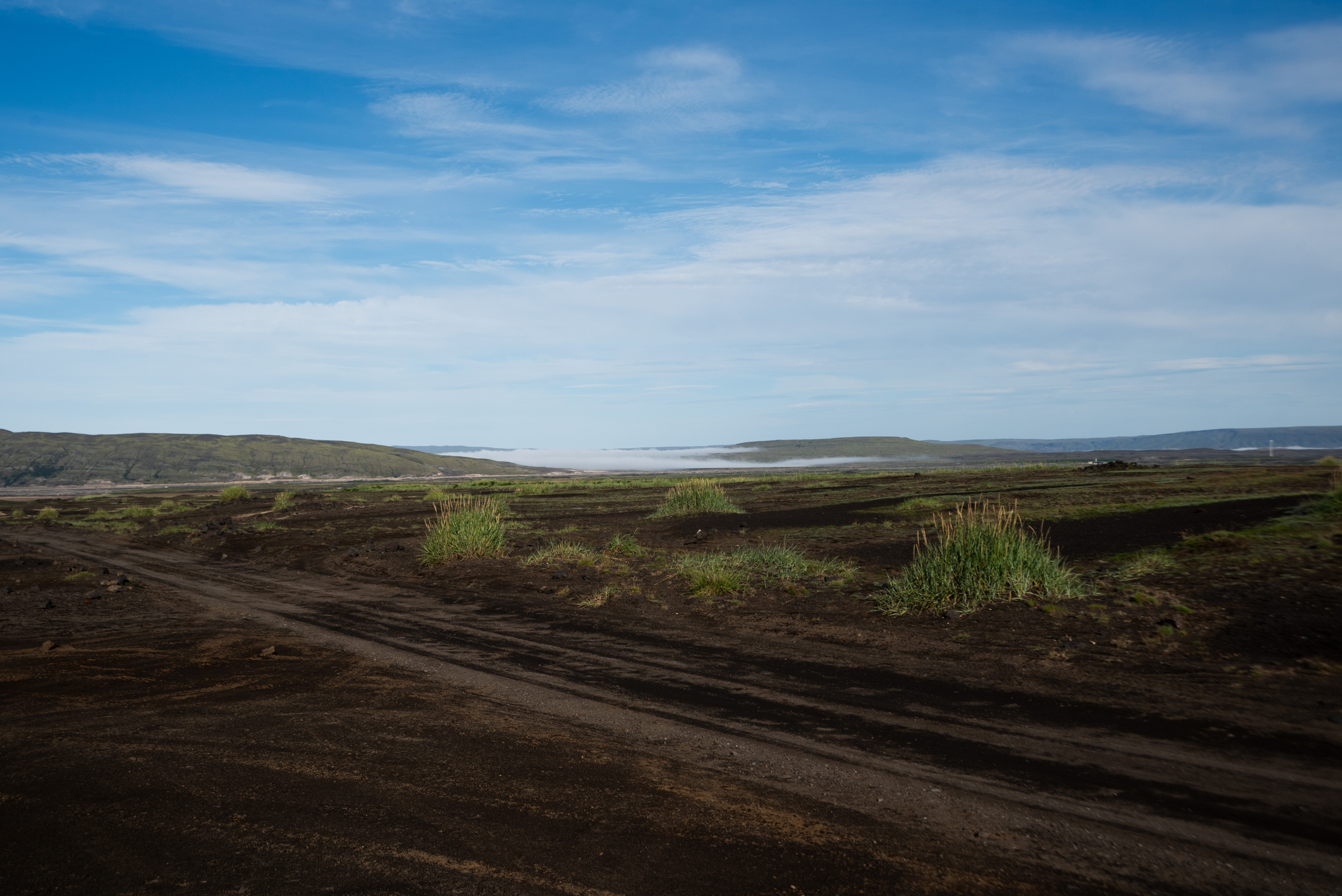
I drove to Landmannalaugar in a Suzuki Jimny. After 50 to 60 kilometres of highland track, both the vehicle and the occupants had been thoroughly shaken. Small vehicles with short wheelbases feel every rock. The Jimny was capable — but the physical demand of the drive was greater than I had anticipated, and the time it took was considerably longer than the distance suggested.
Driving F-Roads: What Experience Has Taught Me
Speed and following distance
Drive slowly. This sounds obvious and is consistently ignored. F-roads are not gravel roads in the conventional sense — the surface changes without warning, and what looks like a smooth section can conceal a rut or a loose rock that unsettles the vehicle.
Never drive directly behind another vehicle. Flying stones are a genuine hazard — a vehicle ahead of you throws debris backward at speed, and at close following distance you have no time to react. Keep a significant gap and let the vehicle ahead disappear around corners before you follow.
Blind crests
F-roads frequently climb over ridges and crests with no visibility of what is on the other side. Approach every crest as if there is a vehicle coming the other way — because there may be. Move to the right, reduce speed, and be prepared to stop.
Gradients
Steep descents on F-roads require low-range gearing and a slow, controlled approach. Do not ride the brakes on a long descent — use engine braking. On the way up, momentum matters more than on tarmac — assess the gradient before you start the climb and commit to a steady speed rather than losing momentum halfway.
Getting used to it
After a certain distance on F-roads, the driving becomes more intuitive. The rhythm of reading the surface ahead, adjusting speed for changing conditions, and managing the vehicle’s reactions becomes more natural. What feels demanding at kilometre five is more manageable at kilometre thirty. This is not a reason to relax your attention — it is a reason to persist through the initial discomfort rather than turning around too early.
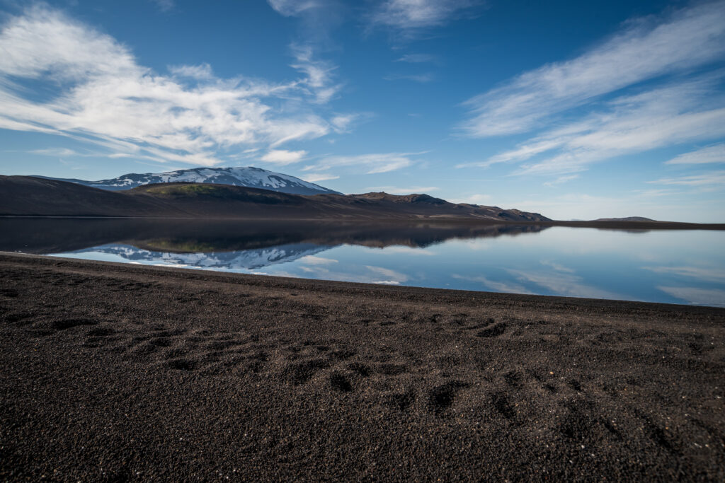
River Crossings — Take Them Seriously
River crossings are the most technically demanding element of F-road driving and the one where mistakes have the most serious consequences. A vehicle swept off course in a glacial river is not a recoverable situation.
River Crossings
Go or turn back — the decision you must make at every crossing
Before every crossing — in this order
Landmannalaugar, 2021: The crossing at the campground was passable for vehicles with sufficient ground clearance — but not for the Suzuki Jimny we were driving. There was a car park on our side of the river and a small footbridge for pedestrians. We parked, crossed on foot, and saw Landmannalaugar from there. This was not a failure. Knowing when to stop is the most important F-road skill there is.
Before every crossing:
- Stop the vehicle and get out
- Walk the crossing on foot — assess the depth, the current strength, the riverbed surface, and the exit point on the far side
- Look for other vehicles crossing or having crossed recently — fresh tyre tracks indicate a passable line
- If you have any doubt about the vehicle’s capability relative to the crossing, do not attempt it
At Landmannalaugar, the final approach to the campground crosses a river that varies in depth and flow depending on recent conditions. On our visit, the crossing was passable for vehicles with sufficient ground clearance — but not for ours. There was a car park on our side of the river and a small footbridge for pedestrians. We parked, crossed on foot, and saw Landmannalaugar from there.
This was not a failure. It was the correct decision, made by assessing the actual conditions rather than the plan. Knowing when to stop is a skill — and in Iceland’s highlands, it is one of the most important ones.
If you decide to cross:
- Engage 4WD and differential lock before entering the water
- Choose a line and commit to it — do not stop in the middle of the crossing
- Maintain a steady, consistent speed — not fast, not slow
- Do not change gear mid-crossing
- Windows down — if the vehicle stalls in the water, you need to be able to exit
What to Carry
F-road driving in Iceland’s interior is remote driving. Mobile coverage is limited or absent across much of the highland network. If something goes wrong, help is not immediately available.
Before You Drive
F-road kit checklist — what stays in the vehicle at all times
Food & Water
Clothing
Vehicle Recovery
Navigation & Communication
Tell someone your plan. Before driving a significant F-road route, inform your accommodation or another person of your intended route and expected return time.
Leave No Trace — The Highland Imperative
Off-road driving in Iceland’s highlands is illegal. This is not a grey area — driving outside the marked F-road track causes permanent damage to Iceland’s highland vegetation and soil structure, and it is enforced. Fines are significant.
The temptation exists. A photographic location is visible from the road but requires a short drive across open ground to reach. The ground looks solid. It is not the right decision.
Iceland’s highland vegetation recovers over decades, not seasons. Tyre tracks through highland tundra are visible for years. The photography community has been specifically identified as a source of off-road pressure at remote locations. Stay on the road.
This applies equally to parking. Park on rock or established parking areas only. Parking on vegetation causes the same damage as driving on it.
Highland Locations
Three destinations worth the F-road drive
Opening dates vary every year. Do not rely on last year’s dates, travel blogs with fixed month windows, or advice from other travellers at the petrol station. The only reliable source is road.is — check it before every drive.
Highland Photography Locations Worth the Drive
Landmannalaugar
The most accessible of Iceland’s major highland destinations and one of the most visually distinctive landscapes in the country. The rhyolite mountains — banded in green, red, yellow, and purple from mineral deposits laid down by ancient eruptions — produce colours that look processed even when they are not. The geothermal hot spring at the campground adds a human element that aurora photographers use as a foreground.
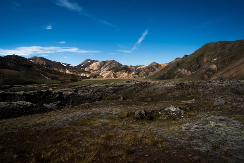
The drive from the Ring Road is approximately 80 kilometres on the F208 — allow two to three hours depending on conditions. The river crossing at the campground is the variable that determines whether you reach the site directly or park and walk.
Drone flight is prohibited at Landmannalaugar between June 15th and September 15th. Check current restrictions at ust.is.
Kerlingarfjöll
Less visited than Landmannalaugar and arguably more dramatic — the geothermal fields at Kerlingarfjöll produce steam columns rising from coloured clay hillsides in a landscape that feels genuinely otherworldly. The access road is the F35 (Kjölur route), one of Iceland’s more straightforward highland roads.
The Kjölur Route (F35)
The most accessible F-road for photographers who want highland experience without the most technical river crossings. The route crosses the interior between the two main glacier systems and passes Hveravellir — a geothermal area with hot pools and remarkable mineral formations — before descending to the north.
Practical Summary
| Topic | Key point |
|---|---|
| Vehicle requirement | 4WD mandatory — legal requirement, not suggestion |
| Opening dates | Variable — check road.is before every drive |
| River crossings | Stop, assess on foot, commit or turn back |
| Speed | Slow — consistently slower than you think necessary |
| Following distance | Large — flying stones are a real hazard |
| Off-road driving | Illegal and causes permanent damage |
| Emergency number | 112 — download the 112 Iceland app |
Further Reading
- Photography in Iceland: The Complete Responsible Guide
- Iceland in Winter for Photographers: October to March — F-roads are closed in winter
- Leave No Trace in Iceland: A Photographer’s Guide
- Vegagerðin (Icelandic Road Administration) — road.is
Sources
- Vegagerðin (Icelandic Road Administration) — road.is
- Umhverfisstofnun (Environment Agency of Iceland) — ust.is
- Ferðamálastofa (Icelandic Tourist Board) — visiticeland.com