A landscape that keeps revealing itself
The Mývatn region is one of those places in Iceland where a single day feels insufficient and two days leave you with a list of things you missed. The lake, the lava formations, the geothermal fields, the crater, the caves — each one is a subject in its own right, and they sit within a compact area that can be driven in an hour but photographed for a week.
I have been here multiple times, in different seasons. The winter version of Mývatn — snow covering the lava formations, ice at the lake’s edges, the light flat and grey and full of atmosphere — is a different place from the summer version, which brings long daylight and one of Iceland’s more memorable wildlife experiences: insect swarms of a scale that has to be witnessed to be understood. More on that shortly.
The region sits in a zone of intense geothermal and volcanic activity. What you are photographing here is not a scenic lake with some interesting rocks — it is an active geological system that has been building and reshaping itself for millennia, and that continues to do so. That context belongs in every image you make here.
Location Overview
Six locations — what the Mývatn region offers photographically
Recommended minimum stay: Two full days for the core locations. Three gives you flexibility to respond to light and weather — and to visit Goðafoss and Dettifoss in the same trip without rushing. Reykjahlíð is the practical base; book accommodation early in summer.
The Lake
Lake Mývatn itself is a shallow, nutrient-rich lake formed by a basaltic lava eruption approximately 2,300 years ago. The lava blocked the river and created the lake basin; the pseudocraters along its southern shore are the result of steam explosions where lava flowed over wet ground. The lake is one of Iceland’s most important bird habitats — in summer, the diversity and density of waterfowl here is remarkable.
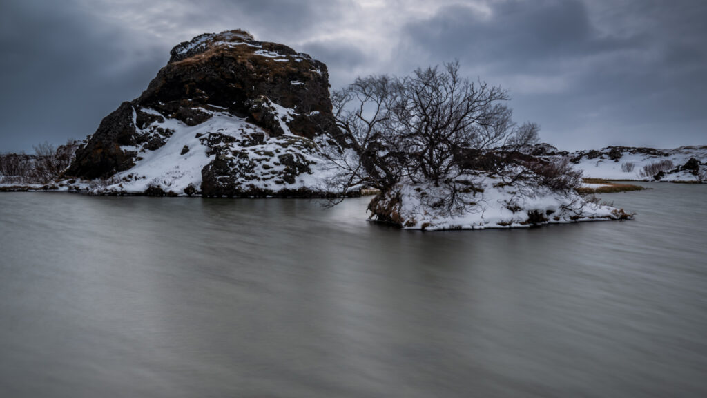
Photographically, the lake rewards patience and low positions. The pseudocraters on the south shore give you elevated viewpoints over the water and the surrounding lava landscape. The small lava islands that break the surface — some with wind-bent trees clinging to them — work beautifully as foreground elements in long exposures where the water surface becomes a soft plane of grey or silver.
In winter, as in the image above, those same islands sit in near-still water with snow on their surfaces and bare branches against a heavy sky. The stillness is complete. The only sound is the wind.
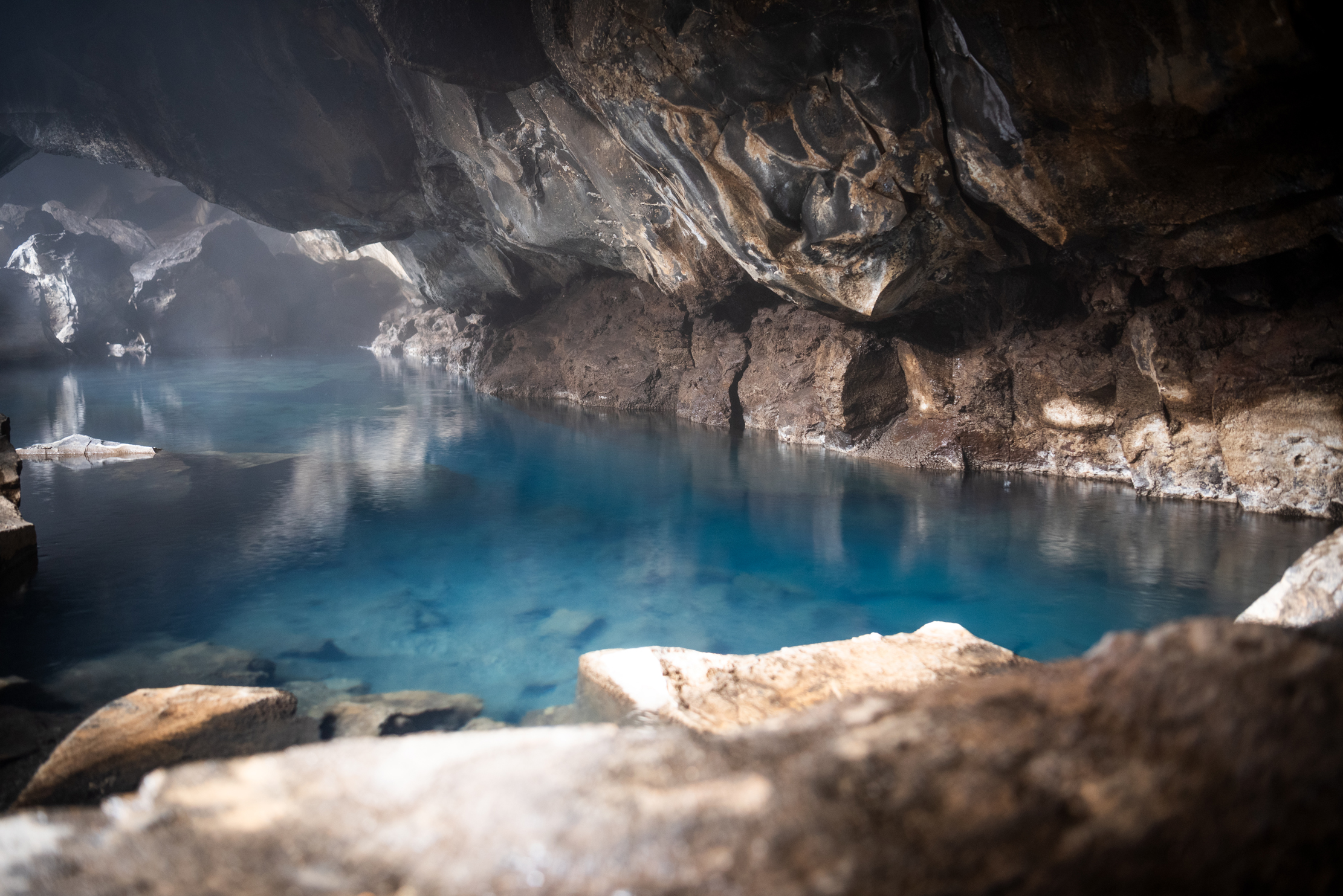
Grjótagjá — The Cave You Cannot Swim In
Grjótagjá is a small lava cave a short drive east of the lake, containing a geothermal hot spring of extraordinary visual quality. The water is a clear, luminous blue. Shafts of light enter through the cave opening and hit the surface at angles that shift through the day. Steam rises from the water and diffuses the light inside the cave in a way that makes photography here feel almost staged — except that it is entirely natural.
Grjótagjá Cave
Photography inside the cave — technique and timing
Starting point settings for Grjótagjá
No swimming — and this is enforced. The water temperature is 43–50°C and fluctuates unpredictably. The cave is on private land. Photography is welcome; entering the water is not. The prohibition exists for safety, not aesthetics.
I visited in 2022. The cave is not large, and the descent from the entrance to the water’s edge involves navigating uneven rock in low light. Sturdy footwear matters more than it might seem.
Swimming is prohibited — and has been for decades. During volcanic eruptions between 1975 and 1984, water temperatures rose to as high as 60–70°C, making the spring completely unusable. Temperatures have since stabilised at around 43–50°C, but remain too hot for safe bathing and fluctuate unpredictably. The cave is on private land and the prohibition is enforced. The water is for looking at and photographing — not entering.
The cave also appeared in Game of Thrones — the Jon Snow and Ygritte scene in season 3, episode 5. The actual love scene was shot in a studio, but the cave’s setting was used. It has brought a surge of visitors who arrive looking for the specific angle from the screen. The cave is worth visiting entirely independently of that connection.
Photographic tips for Grjótagjá:
- Visit around midday when light from the cave entrance hits the water most directly — the shafts of light and surface reflections are at their strongest
- A wide angle lens at low position near the water’s edge captures both the cave ceiling and the full pool surface
- The exposure challenge is significant: bright light from the entrance versus dark cave interior. Bracket exposures or use HDR technique, or expose for the water and let the ceiling go dark — both produce strong results
- A tripod is essential — the interior is dark and the light from outside creates a challenging dynamic range
Alternative: Stóragjá Approximately 1.5 kilometres from Grjótagjá, the lesser-known Stóragjá cave has a geothermal pool with significantly lower temperatures — around 29–30°C — and has historically allowed bathing. Check current conditions locally before visiting. The cave is less visited and less photographed than Grjótagjá, which makes it worth the short detour.
Dimmuborgir — The Dark Castles
Dimmuborgir — “dark castles” — is a lava field east of the lake where an ancient lava flow solidified around steam vents and columns of lava, leaving behind an extraordinary landscape of pillars, arches, caves, and towers. Walking through it feels like moving through a geological fairy tale.
The formations range from small pillars you can step around to structures several metres high. The most famous single formation is Kirkjan — “the Church” — a natural arch large enough to stand inside, with the light coming through the opening in a way that rewards a wide angle lens pointed toward it.
Photographic tips:
- Visit in early morning or late evening when low-angle light creates shadow and depth in the formations — midday flat light reduces the three-dimensional quality of the rock
- The marked trails through Dimmuborgir are essential — the lava around the formations is sharp, unstable, and easily damaged. Stay on paths
- Fog or overcast conditions add atmosphere — the formations disappear into grey and re-emerge, which suits the “dark castle” character of the place
- In winter, snow on the tops of the lava pillars against dark rock creates strong tonal contrast
Hverfjall — The Tephra Crater
Hverfjall is one of the world’s largest and best-preserved tephra craters — a near-perfect ring of volcanic ash and scoria approximately 1 kilometre in diameter and 140 metres deep. From the crater rim, the views extend across the lake, the lava landscape, and to the mountains beyond.
The climb to the rim takes approximately 20–30 minutes from the car park. The path is marked and must be followed — the tephra surface is fragile and highly erosion-prone. Previous visitor damage has led to restrictions, and the current path system represents a compromise between access and preservation.
Photographic tips:
- The view from the eastern rim gives you the full crater interior with the lake visible in the background — the classic composition
- Golden hour from the rim in summer produces extraordinary light across the entire Mývatn landscape
- The crater itself is the subject in winter — snow fills the interior unevenly, following the contours of the tephra, and the monochrome quality of the scene works strongly in black and white
Námaskarð — The Geothermal Field
Námaskarð, also known as Hverir, is a high-temperature geothermal area on the slopes of the Námafjall ridge, directly accessible from the Ring Road. Bubbling mud pools, fumaroles venting sulphurous steam, and coloured clay hillsides in orange, yellow, and red create a landscape that looks more like another planet than northern Iceland.
The smell is significant — hydrogen sulphide is pervasive. You adjust to it quickly enough to photograph without distraction, but it is worth knowing in advance.
Photographic tips:
- The steam columns from the fumaroles work best backlit — position yourself so the light comes through the steam rather than from behind you
- A wide angle lens captures the scale of the field; a short telephoto isolates individual mud pools and their surface texture
- The coloured clay hillsides behind the geothermal area reward a longer focal length — the colour banding is more visible when compressed
- Visiting in wind is complicated — steam blows unpredictably and may obscure your composition or blow toward you
Leave No Trace at Námaskarð: The ground around the mud pools and fumaroles is thin and unstable. Stepping off the marked paths risks breaking through the crust into water or mud at extremely high temperatures. This is not a theoretical warning — it is a documented hazard at geothermal areas across Iceland. Stay on the paths without exception.
Drone Rules
Drone use in the Mývatn area requires a permit from the Nature Conservation Agency of Iceland — nattura.is. This applies to the lake itself, Hverfjall crater, and Dimmuborgir. Importantly, the Mývatn area is classified as particularly sensitive — permit processing takes up to 30 days, significantly longer than other areas. Apply well in advance of your trip. The area’s rich birdlife is the primary reason for the restrictions.
Mývatn Nature Baths
The Mývatn Nature Baths — Jarðböðin — are a developed geothermal bathing facility on the lake’s north shore, often described as the north Iceland equivalent of the Blue Lagoon. The water is warm, milky blue, and sits against a backdrop of the lava landscape and lake.
Drone photography above the baths is prohibited — for obvious privacy reasons. Photography within the facility follows standard bathing area etiquette: photograph the landscape and the water, not other bathers without consent.
As a photography subject, the baths work best at the edges where the water meets the lava — early morning or late evening when steam rises in the cool air and the light catches the water surface.
I visited the Mývatn Nature Baths and found them genuinely pleasant — considerably quieter and more affordable than the Blue Lagoon, and the setting against the lava landscape is hard to fault. Once was enough for me personally. If you are looking for a geothermal bathing experience in the region that feels less developed and more connected to the surroundings, the Geosea in Húsavík — approximately 45 minutes north — is worth considering. The infinity pool design sits directly above the sea, and the view across Skjálfandi Bay toward the mountains is extraordinary. Both are worth knowing about; which one suits you depends on what you are looking for.
Safety
Two hazards at Mývatn that look nothing like hazards
April 2024, Lake Mývatn: I broke through a snow-covered surface into a void in the lava beneath and dislocated my shoulder. The snow looked completely solid. It was not. The landscape under winter snow at Mývatn is not the landscape you can see — it is the invisible geology beneath. The marked paths exist for this reason. Stay on them.
A Safety Note — Snow Conceals More Than You Think
In April 2024, at the edge of Lake Mývatn, I broke through a snow-covered surface into a hole beneath and dislocated my shoulder. The snow looked completely solid. The landscape underneath was not.
This is the specific terrain warning for the Mývatn region in spring: the lava landscape under winter snow is irregular, full of cavities, and completely invisible from above. What appears to be a flat, safe surface between formations may have voids beneath it that a footstep will collapse. The pseudocraters and lava field edges are particularly deceptive.
Stay on marked paths. If a composition requires you to leave a path in snowy conditions, assess the ground carefully before committing your full weight to it — and ideally, don’t leave the path at all.
The Insect Situation
In summer, Lake Mývatn produces midges in numbers that define the experience as much as the landscape does — the lake’s name translates roughly as “midge lake,” which is accurate. Worth knowing: there are two species. The lake midges (Chironomidae) do not bite and are merely annoying. The black flies (Simuliidae) do bite, and their bites can itch for a long time.
A midge head net is worth packing for any summer visit. In August 2025, the lake saw its largest midge swarm in decades following a four-year population decline — so current conditions are particularly intense. The birds love the midges — they are the reason the lake supports such extraordinary waterfowl diversity. The midges are the price of admission.
Getting There
Lake Mývatn sits on the Ring Road (Route 1) in north Iceland, approximately 100 kilometres east of Akureyri. All major locations in the region are accessible by road, with Reykjahlíð as the practical base.
From Akureyri: Approximately 1 hour via Route 1. From Dettifoss (west bank): Approximately 30 minutes via Route 1 and Route 862. From Húsavík: Approximately 45 minutes.
Accommodation in the region — guesthouses and the hotel at the lake — books quickly in summer. Plan ahead.
Sources
- Nature Conservation Agency of Iceland — nattura.is
- Veðurstofa Íslands (Icelandic Meteorological Office) — vedur.is
- Vegagerðin (Icelandic Road Administration) — road.is
- Ferðamálastofa (Icelandic Tourist Board) — visiticeland.com