Iceland in miniature — if you take the time to look past the obvious
The Snæfellsnes Peninsula is often described as “Iceland in miniature” — and the description is accurate. Within a hundred kilometres of coastline, the peninsula concentrates glacier, lava field, black pebble beach, sea cliff, fishing village, and volcanic mountain into a compact area that a single day trip from Reykjavík can only scratch the surface of.
Most visitors do exactly that — a day trip, Kirkjufell, a waterfall, back to the capital. The peninsula rewards something different: slowing down, staying overnight, and letting the places that are not on the itinerary become the ones you remember.
I visited in October 2021, on the way north to the Westfjords. The weather was what Iceland’s west coast delivers in October — rain, low cloud, and wind that at one point on Súgandisey island was strong enough that you could lean into it at a full angle without falling. We did not complete the full peninsula circuit. What we saw was enough to put a proper return visit on the list for 2027.
At a Glance
Snæfellsnes Peninsula — Key Facts for Photographers
Marcel’s recommendation: Stay in Grundarfjörður, eat at Bjargarsteinn, use the peninsula as the first night of a route continuing north to the Westfjords. The combination rewards the travel time far more than a day trip does.
Getting There and Getting Around
Snæfellsnes is approximately two hours from Reykjavík via Route 54. The Ring Road does not pass through the peninsula — it requires a deliberate detour, which is part of why it sees fewer visitors than the south coast despite being easily accessible.
A rental car is essential. The peninsula’s highlights are spread across both the north and south coasts, and public transport does not cover most of them. Route 54 and Route 574 form the main circuit — both are paved and accessible year-round, though winter driving requires standard caution and a 4WD vehicle in poor conditions.
Allow at least two days. A day trip from Reykjavík is possible but produces a rushed experience. Staying overnight — ideally in Grundarfjörður or Stykkishólmur — allows you to be in position for morning light and to move without the pressure of a return drive.
Where to Stay: A Personal Recommendation
We stayed in Grundarfjörður and had dinner at Bjargarsteinn — a restaurant overlooking the fjord that I would recommend without hesitation. It was the kind of meal that sets the tone for a trip: local, unhurried, and exactly right for the setting. If you are planning a Snæfellsnes visit that continues north to the Westfjords, Grundarfjörður is a natural first night and an excellent base.
Key Locations
Location Overview
Six locations — what each one offers photographically
The full circuit — Kirkjufell, Grundarfoss, Súgandisey, Djúpalónssandur, Arnarstapi, Hellnar, and the glacier — requires a minimum of two full days. Three allows you to respond to weather and light rather than chasing a fixed schedule.
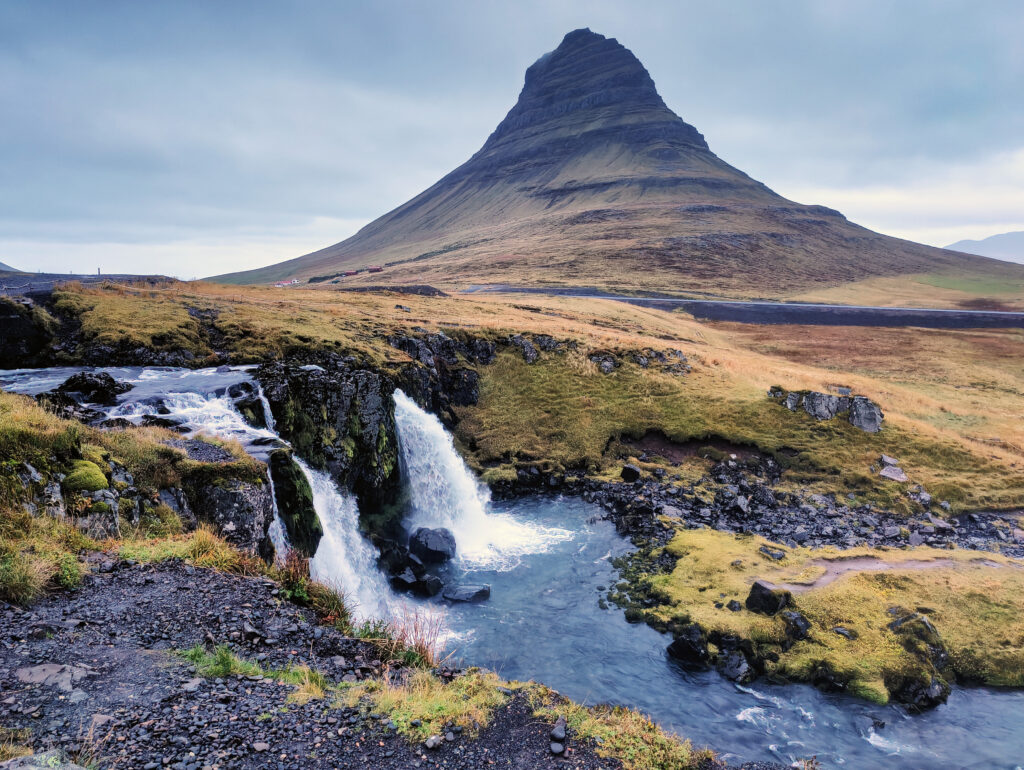
Kirkjufell and Kirkjufellsfoss — the honest assessment
Kirkjufell is the most photographed mountain in Iceland. The distinctive conical peak, combined with the small waterfalls of Kirkjufellsfoss in the foreground, has appeared in photography collections, travel magazines, and television productions to the point where the image is genuinely iconic.
It is also genuinely crowded — in summer, at the popular shooting position beside the waterfalls, you are negotiating tripod space with dozens of other photographers. Sunrise and sunset bring the largest concentrations. The car park fills early.
My experience was different, and not by design. I arrived in the rain, in October, with no particular expectation — I knew there was a small waterfall worth seeing, and I wanted to find it. There was no one else there. I set up, photographed the falls, and moved on. It was only considerably later, reviewing the images and recognising the mountain behind the water, that I realised where I had been.
I had photographed Kirkjufell entirely by accident, in the rain, alone.
The lesson I take from this: the location is spectacular regardless of the crowds — but the crowds are manageable if you visit in the shoulder season, in poor weather, or early enough in the morning that you arrive before the tour buses. October in the rain is not a consolation prize. It is a different and arguably more honest version of the place.
Photographic tips:
- The classic composition positions the waterfalls in the foreground with the mountain behind — a wide angle lens (16–24mm) at the established shooting position beside the stream covers this well
- The mountain itself, photographed from further back with a short telephoto, shows its full conical profile against the sky — a composition that the waterfall foreground obscures
- Morning light from the east catches the mountain face directly — arrive before sunrise and wait – Use the Iceland Light Calculator to find exact sunrise and golden hour times for Snæfellsnes — arriving in the right window makes the difference between flat light and the warm side-lit conditions that make Kirkjufell’s profile unmistakable.
- In winter, snow on the peak and ice on the waterfalls transform the location entirely
- Aurora photographers use Kirkjufell as a foreground — the mountain’s distinctive silhouette is immediately recognisable against a lit sky
Leave No Trace: The area around Kirkjufellsfoss is heavily visited and the vegetation shows it. Stay on the established paths and shooting positions. The temptation to find a slightly different angle by stepping off the path is understandable — resist it.
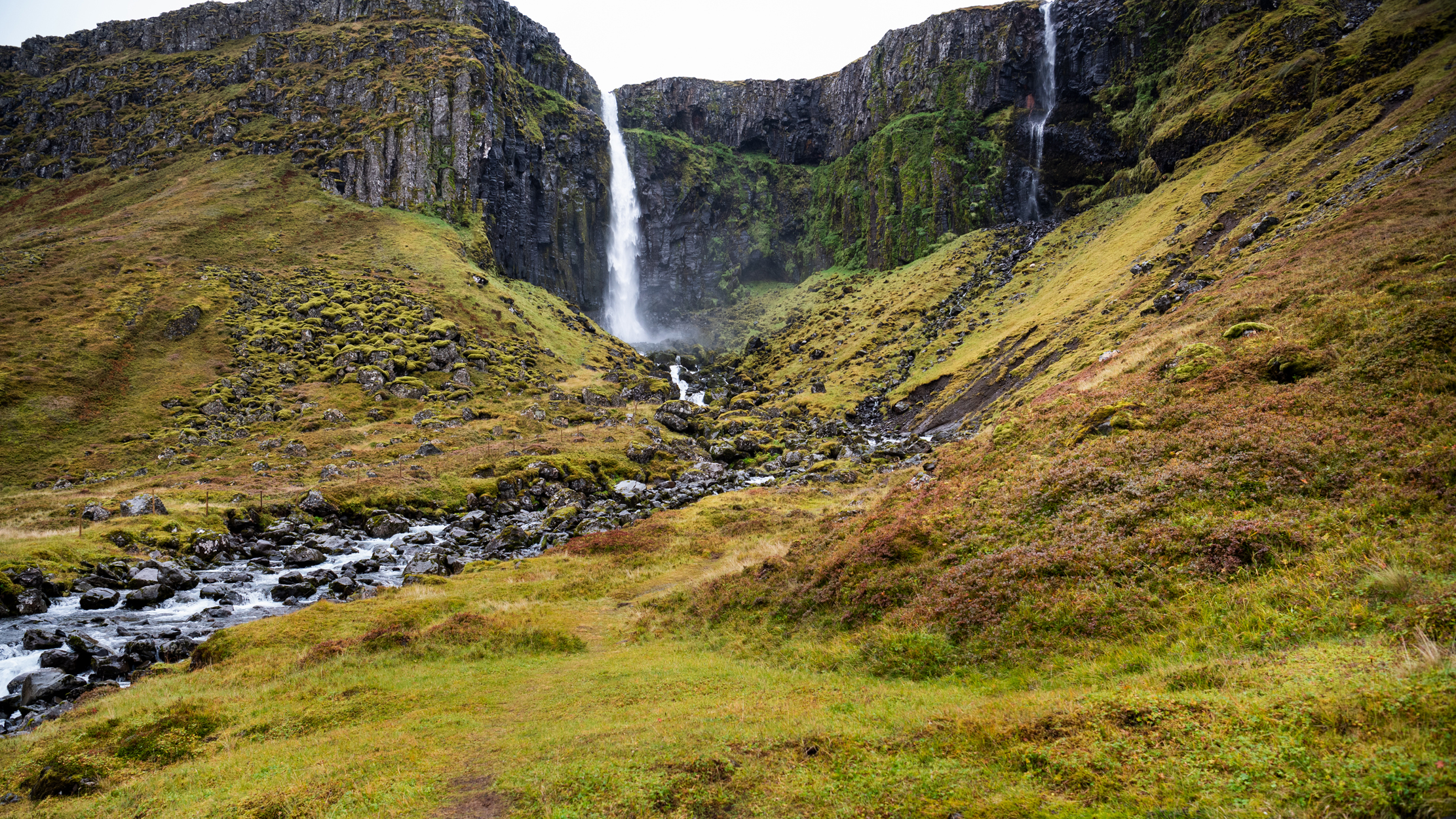
Grundarfoss — the waterfall most visitors miss
A short distance from Grundarfjörður, largely overlooked by the Kirkjufell-focused visitor flow, Grundarfoss drops through a dramatic basalt canyon into a green valley that in October carries the warm tones of autumn. Two separate falls drop from the cliff face — the main cascade and a narrower secondary fall to the right — creating a composition with natural depth and scale.
I found the atmosphere at Grundarfoss more immediately engaging than at Kirkjufellsfoss. The scale of the canyon walls gives the waterfall a sense of drama that the more famous location, for all its mountain backdrop, does not quite match. And the absence of other visitors — at least in October — allowed the kind of unhurried work that Iceland’s best locations reward.
Photographic tips:
- Approach from the valley floor for the full canyon-and-waterfall composition — the basalt walls frame the falls naturally
- A medium telephoto (70–100mm) isolates the main fall against the cliff face and compresses the canyon walls effectively
- An ND filter extends the exposure and smooths the water — the dual-fall composition benefits from the motion being rendered as texture rather than frozen spray
- Autumn colour in the foreground grass and hillside adds warmth to what would otherwise be a cool, grey-dominated scene
Súgandisey — the lighthouse island
Connected to Stykkishólmur by a short causeway, Súgandisey is a small island topped by a lighthouse with views across the fjord and the surrounding peninsula. It is a short walk from the town and frequently overlooked by visitors focused on the larger attractions.
The photographic interest is primarily in the views back toward the mainland — the fjord, the mountains, and the town of Stykkishólmur below. In good light, the combination of harbour, water, and mountain backdrop is quietly beautiful.
A practical note: the wind on Súgandisey can be extraordinary. On our visit it was strong enough that leaning into it at a significant angle was not a metaphor — it was the only way to remain upright. For photographers, this means tripod stability becomes critical, and handheld shooting at slow shutter speeds is not realistic. Plant your feet, weight your tripod, and keep your centre of gravity low.
Snæfellsjökull Glacier
The glacier that dominates the peninsula’s western tip — and Jules Verne’s imagination — is the defining visual anchor of Snæfellsnes. On clear days, the ice cap is visible from Reykjavík across the bay. On the peninsula itself, it appears at the end of roads and above ridgelines with a scale that the photographs rarely convey.
The glacier sits within Snæfellsjökull National Park. Access to the glacier itself requires a guided tour — solo glacier walking is prohibited for safety reasons, and the usual regulations around drones and protected areas apply. Check current access conditions with Umhverfisstofnun before your visit.
Photographically, the glacier works best as a backdrop — its presence behind a lava field foreground, a fishing boat in a harbour, or the black pebble beaches of the south coast creates the kind of layered composition that defines the peninsula’s visual character.
Djúpalónssandur — the black pebble beach
On the peninsula’s southwest coast, Djúpalónssandur is a black pebble beach with an unusual historical element: the rusting remains of a British trawler that wrecked here in 1948 are scattered across the beach and have been left in place as a memorial.
The combination of black pebbles, rusting metal, sea stacks offshore, and the glacier visible to the north produces a photographic environment with more layers than most Iceland beaches offer. The lifting stones near the beach entrance — used historically to test the strength of fishermen — add a human element that grounds the location in the place’s history.
Leave No Trace: The pebbles at Djúpalónssandur are protected. Do not remove them — not as souvenirs, not as weights for your tripod bag. The wreck debris is also protected and should not be moved or disturbed.
Arnarstapi and the Sea Cliffs
On the south coast, the village of Arnarstapi sits at the base of dramatic sea cliffs riddled with caves, arches, and basalt formations carved by the Atlantic. A coastal path connects Arnarstapi to the neighbouring village of Hellnar — a walk of approximately 2.5 kilometres that passes some of the most photographically interesting coastal geology on the peninsula.
The combination of sea arch, breaking wave, and glacier backdrop in a single composition is available here in a way that requires no particular planning — simply walking the path at the right time of day puts you in front of it.
Note on seasonal access: Drone flight at Arnarstapi is prohibited between April 15th and September 15th due to nesting seabirds. The cliffs host significant bird colonies during this period. Check current restrictions before flying.
What a Full Visit Looks Like
My 2021 visit covered Kirkjufellsfoss, Grundarfoss, and Súgandisey before continuing north. A full circuit of the peninsula — the one planned for May 2027 — would add Djúpalónssandur, Arnarstapi, Hellnar, the glacier, and the south coast between Arnarstapi and Vík on the peninsula’s tip.
Allow a minimum of two full days. Three is better. The peninsula’s scale is deceptive — the roads follow the coastline rather than cutting across, and distances take longer than a map suggests.
Leave No Trace
Snæfellsnes is one of Iceland’s most visited regions outside the south coast, and the pressure on specific locations is visible. A few location-specific reminders:
Leave No Trace — Snæfellsnes
Location-specific rules across the peninsula
Kirkjufellsfoss: Stay on established paths. The vegetation around the stream is fragile and heavily used.
Djúpalónssandur: No pebble removal. No disturbance of the wreck debris.
Snæfellsjökull National Park: Standard national park rules apply — no drone flight without a permit, stay on marked paths, no removal of rocks or vegetation.
Arnarstapi cliffs: No approach to nesting areas between April and September. The coastal path is marked — use it.
Practical Information
Best season: May through October for full access. May offers spring light and early puffin activity without summer crowds. October offers autumn colour, reduced visitors, and the possibility of Northern Lights — at the cost of some unpredictable weather.
Accommodation: Grundarfjörður, Stykkishólmur, and Arnarstapi all have options. Book in advance for summer visits.
Weather: The peninsula’s west-facing coastline is fully exposed to Atlantic weather. Conditions change quickly. Check Veðurstofa Íslands daily and build flexibility into the itinerary.
Further Reading
- Photography in Iceland: The Complete Responsible Guide
- Photographing the Westfjords: Iceland’s Forgotten Region — the natural next destination heading north
- Leave No Trace in Iceland: A Photographer’s Guide
- Best Time to Visit Iceland for Photography
Sources
- Umhverfisstofnun (Environment Agency of Iceland) — ust.is
- Ferðamálastofa (Icelandic Tourist Board) — visiticeland.com
- Veðurstofa Íslands (Icelandic Meteorological Office) — vedur.is
- Snæfellsjökull National Park — ust.is